AFFORDABLE, ACCURATE NAVIGATION
STORY // Ong Hong Tat
PHOTO // Chai Sian Liang
Need to report an enemy location to headquarters?
There's an app for that! For US$3.99 (S$5.16), you can have military-grade navigation capabilities in the palm of your hand.
| TECH SPECS | ||
|---|---|---|
| App Name | Tactical NAV app (for Apple iPhones) | |
| Operating System | iOS only | |
| File Size | 6MB | |
| Availability | On sale now at the Apple App Store for US$3.99 | |
Just 10 years ago, if anyone had said they could use their mobile phones to call up maps and give them turn-by-turn directions, you would have thought that they were not quite right in the head.
Fast-forward to present day and mobile phones with such functions have become an essential part of many people's lives.
Taking this now-ubiquitous navigation technology further is the Tactical NAV application developed by Captain (CAPT) Jonathan Springer of the United States Army, who put US$30,000 of his own money into developing the app after a fatal incident which took the lives of two friends deployed in Afghanistan.
Pinpoint accuracy
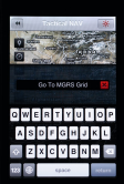
The app puts the Military Grid Reference System (MGRS), field navigation tools and more into the hands of a smartphone-toting soldier. A navigational standard employed by North Atlantic Treaty Organisation (NATO) armed forces, MGRS assigns a specific set of numbers - called grid references - for any point on Earth. The more numbers in a grid reference, the more accurate the position.
In harsh operating environments where there are little or no distinguishing landmarks, these numbers can also help to move forces where they are most needed. They are also the numbers which soldiers use to call for support fire.
At your fingertips
The ability to easily make sense of and derive these precise MGRS coordinates is what the Tactical NAV app is all about.
To locate a position, simply key in the coordinates and a corresponding map of that point is almost instantly displayed on-screen. The app also automatically displays your current position and its MGRS coordinates with the touch of a button.
Combine that with the ability to snap photos with embedded MGRS coordinates along with the usual time and date stamping functionality and the app becomes a reporting tool.
For example, a commander of a small unit spots suspicious structures but is unable to investigate due to mission constraints. With the app, he can simply snap a photo (stamped with the vital location data) and send the image to headquarters for further analysis.
The app also includes a feature to share the location via e-mail or multimedia messaging, which uses robust 256-bit encryption as a security measure.
Good complement
Before the advent of the Global Positioning System (GPS) in 1995, military commanders navigated manually by plotting their positions on topographical maps. Nowadays, military commanders in the field make use of three separate pieces of equipment to navigate: a map, a compass and a hand-held GPS device.
Military GPS devices make use of the same satellites used by the civilian system but with far fewer restrictions. They are more accurate and also hardened to prevent signal-jamming technologies from disrupting their operation.
One of these devices is the Defence Advanced GPS Receiver used by the US military. Weighing in at almost half a kilogramme and the size of a large slab of chocolate, it is issued only to some members (usually commanders of ground units) of the US Army.
This is one gap which the Tactical NAV app could fill by putting basic electronic navigation capabilities in the hands of every soldier who has a smartphone. The app has been put to use in Afghanistan by members of the US Army to alert one another of potential danger, though the app is not formally supported by the US Department of Defence.
Never lost
With the ability to save various points along a route, users can backtrack their paths to find their way to base. This feature is called up with the "drop point" button within the app and each location is numbered accordingly.
For example, a soldier may save his first starting point as his "base" and proceed to log the individual locations visited. When it is time to return, he can simply follow the waypoints in the reverse order or even plot a different path back to base.
Field-ready
To cut glare from the screen, the app includes a night mode feature. One click turns the screen a dull red colour, which is said to be the least disruptive light spectrum to night vision.
Saved waypoints are also easily scrollable via the large panel on the bottom of the app screen. This is a boon to soldiers wearing thin gloves when operating the app.
In fact, the app has proven useful even to civilian users such as recreational hunters and hikers. The app is available for download at the Apple App Store, and there are also plans to extend it to Android smartphones.
"I've received numerous emails from soldiers who use the app in both tactical environments overseas, and back at home during training," said CAPT Springer.
"During the summer of 2011, I received an e-mail from a contractor in Kabul, Afghanistan, who told me that Tactical NAV helped direct a UAV (unmanned aerial vehicle) to an enemy location that was conducting attacks against the base - the UAV was able to deter the enemy attack."
"The application allows you to acquire an accurate MGRS coordinate to not only the user's location, but any location in the world - as well as acquire an accurate latitude and longitude."
- Tactical NAV app developer CAPT Springer


-dsc_2181.jpg?sfvrsn=cf8a503f_1)